Saturday 6 June 2015

Auckengill to John O’Groats

The walking party for the last day. Alan, Tom and Rosemary
Susan drove Alan, Rosemary and myself back to the Harbour Brock turn-off in time for a 10:00 start. And it was back on the A99.

I had studied the map assiduously beforehand, and even checked Google Earth in the hope that at least part of the way could be on footpaths rather than the main road. But such hopes were dashed. It would be great if one could cut off the road to the east at Skirza and then travel due north to Duncansby Head, and on by the coastal path to John O’Groats, but there is no footpath immediately north of Skirza. Given previous experiences of trying to cross country with no clearly marked footpaths, this would have been a risk too far – particularly on the last day of the whole walk.

We didn't actually see any pigs. 
So it was back on to the A99, with fervent wishes that the Scottish government would do something to make the northern end of the end-to-end walk more user-friendly. It is fascinating to conjecture (a) what increase in walker numbers would be achieved if the walk was more attractive, and the consequent economic benefit locally; and (b) whether there are any walker injuries on the A9 and A99 as things stand now.

At least on this stage we found that drivers on the A99 were considerate and friendly – they’d wave even if they felt obliged to come to a complete stop to avoid us when there was traffic coming our way. It’s presumably because they’re either locals used to walkers up here, or visitors on their best behaviour.

Rosemary led the way (as she says, her natural walking pace is higher than mine), and for most of the time Alan and I walked together 50 yards or so behind her – talking about everything from our respective schooldays to current science issues and books we had read or felt we ought to read. A pleasant way of passing the time on what was essentially rather a dull walk.

Freswick Castle
All of the country up here is pretty open, with the exception of a few areas of forestry, mostly fairly distant from the road. The differences are still pronounced. At some stages it’s relatively large fields, at others much smaller crofting enclosures. There is also a fairly extensive area of open moorland just before John O’Groats itself, where it becomes crofting fields again. This moorland is heather on peat, with signs of significant historic peak cutting and even some taking place today.

The only building of note on the way is Freswick Castle, now privately owned and advertising itself as a house party or wedding venue.  It’s now owned by Murray Watts, a playwright and author, but its history includes (not surprising given where it is) a period of Sinclair ownership – the family of the Earls of Caithness.  There is also a mausoleum, now largely ruined, and a dovecot.

Given the fact that it was all road walking and not very far anyway, we were at the signpost in John O’Groats signifying the end of the walk shortly by around 12:30.

So it was a short impatient wait until we had the signpost to ourselves, and then time for photographs – just as the rain began. First just me, as the one who had walked (rather slowly!) all the way from Land’s End, and then Rosemary, Alan and myself. The original intention had been to have a glass of champagne there and then, but we deferred the alcoholic part of the celebration until later in the day. So for now it was just coffee and snacks in the rather good café run by Natural Retreats.

Stacks of Duncansby
Later that day we went up to Duncansby Head to make sure that I hadn’t only finished the “official” end to end journey, but had also visited the point on the mainland most distant from Land’s End. This was a much more interesting experience than the last stage of my end-to-end route – fantastic cliffs, huge numbers of nesting fulmars, kittiwakes, auks, shags – the spectacular sight of the Stacks of Duncansby. Well worth the extra few kilometres of walking to see it all. Sunny again, now, but a real gale in our faces as we got back to John O’Groats.

How did I feel? Pleased, and satisfied, that I had completed the walk. But I have to say that the last few days had been disappointing, with few footpaths and too much road walking – mostly on the A9m and A99. One would have liked to finish on a high – great scenery, and wonderful weather. So it was in some ways a bit of an anti-climax.
Finally there!

And now I can start thinking about the next challenge. We shall see!


Bright, with sunny intervals, but getting cloudier towards the end of the morning with a downpour just as we finished the whole walk. 12 to 14C. 11.27 km; 127m of ascents and 143m of descents. A99 all the way.

Friday 5 June 2015

Wick to Auckengill

Sightseeing in Wick - the mash tub at the Old Poultney distillery.
John the distillery man, our guide Katie, and Susan
Alan and Rosemary Towers had arrived the previous evening to join me from the final two days of the walk. In view of the weather (awful) and the route ahead (dull, all unavoidable road walking) they must have had some doubts, but were too polite to voice them. Their loyalty is much appreciated.

So it was off in full battle gear on the road north. First stop – Tesco – for an unappealing selection of sandwiches and alternatives (sushi, in my case, which turned out to be awful as well). And then on with the route march.

The ruined abbey at Wick
There’s really not much positive to say about this part of the world – particularly in weather like this. It’s flat, dull. The houses are undistinguished; some seem as if they’re falling down, others look new but uninhabited. The dominant finish is grey pebbledash. You could be excused to think that no architect had ever made it north of Inverness.

The middle third of the walk was parallel with the dunes behind the wide sandy beaches of Reiss and Keiss. They’re largely hidden by the dune systems behind them. They would be delightful to walk on at low tide in fine weather, but even then there’s the problem of the River of Wester that neatly divides them from one another and would be impossible to ford. In conditions as they were there was no temptation to check them out.

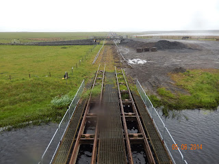
The pipeline manufacturing line at Subsea 7
At the mid-point of the beach there’s a major industrial plant called Subsea 7. There’s a dead straight rail line from it stretching over four and a half miles inland, and I’d had no idea of its purpose. When we crossed it the rails seemed to have been lifted, but they were obviously still working on the track’s bed, with diggers and other heavy equipment laced ready for work. Fortunately an explanation was offered by a tiny plaque on the bridge that crosses the track. It’s a manufacturing plant for underwater pipeline clusters. Presumably great lengths are assembled on the track, and then pulled out to sea for the North Sea oil fields. I imagine that there’s not so much of this work nowadays, but the facility still seems active.

Keiss itself offered nothing. The Sinclair Bay Hotel looked very unwelcoming, and the shop didn’t offer the coffee we’d have welcomed. So it was onwards, with a brief stop at the village war memorial for a quick lunch.

Keiss Castle - in need of a lick of paint
Then it was past Keiss castle – or more accurately, castles. There’s an ancient ruin on the coast, and a newer (18th or 19th Century?) building set back from the shoreline. This shares the Scottish baronial style of Dunrobin and Dunbeath castles, but is in severe need of several coats of new paint. It looks rather sad.

The final stretch was back to the car park at Harbour Brock, just before Auckengill, where Alan had parked the car that morning before our walk. Just as we arrived the heavens opened, and we clambered waterlogged into Alan’s lovely new BMW. And then it was on by car to John O’Groats. It seems rather strange to arrive at one’s intended destination a day early, but there’s really no other accommodation on the way there.

T
Lighthouse at Dunnet Head
hat afternoon it was coffee at the rather good new café, and then a trip to visit the new local boutique gin distillery in Dunnet (very interesting) and then to see the lighthouse and cliffs at Dunnet Head – the most northerly point of the British mainland. Here there are huge numbers of nesting seabirds on the ledges below – including several puffins where there was any room for a burrow.

So there’s only one day to go.


Wet, cold, miserable; not a trace of sunshine until well after we’d finished the day’s walking. 10 to 11C. 16.55 km; 130m of ascents and 93m of descents. A99 all the way.

Thursday 4 June 2015

Whaligoe to Wick

This was to be the day when I could finally get away from the A99 for most of the walk into Wick. Susan dropped me back where I had finished the previous day, and I had only to walk three quarters of a mile before I could leave the A99.

Where's the footpath?
This was down a track that passed a couple of farms before ending at what seemed like a derelict building – though much to my surprise work was being carried out on it. From here the maps – both 1:25,000 and 1:50,000 – showed a path crossing open country and linking up with a minor road at a farm called the Mains of Ulbster. (There are various “Mains of” shown on the maps up here; apparently it means a farm attached to a mansion house.)

Anyway, there was absolutely no sign of anything that could remotely be described as a path. Even getting to its supposed starting point meant climbing over a permanently shut gate. So it was off across country, navigating by reference to the field boundary lines, which do actually correspond with what’s on the ground. It proved to be very difficult going, with three further occasions when I had to cross barbed wire fences, and lots of marshy ground and watery ditches following the rain of recent days.
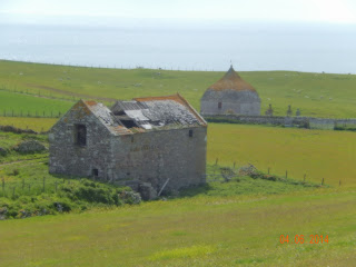
Ruined barn and old mausoleum at Mains of Ulbster

At last as I crested the brow of the hill the Mains of Ulbster came into view. Just as promised by the map there was a mausoleum just beyond it – a rather striking building. Research afterwards says that it’s the Sinclair Mausoleum, and has a date of 1700, though was apparently built from the stones of the earlier St Martin’s chapel. It’s probably too far from anywhere to have become widely known, though it certainly looks as if it’s a building of note.

After this it was about two miles along minor roads – half the spaced out buildings derelict, others in very poor repair, and yet others apparently new and cherished. This seems characteristic of this part of the world. Finally I reached the point beyond the final house where I intended to strike out on what I thought was a footpath to follow the coast.

Local farming practices (1)
The country may be relatively dull, but there’s plenty of bird life to keep one interested. Lots of meadow pipits, oystercatchers, lapwings, sparrows by the farms; the occasional curlew, wheatear, songthrushes in most un-songthrush-like places. The first cuckoo I’d heard in Scotland. At one stage I thought I saw a merlin, but I couldn’t get the field glasses on it quickly enough. The wildflowers are less varied and numerous than elsewhere. But there are patches of bluebells; a fair bit of campion; dandelions; daisies; stitchwort; buttercups;  some violets and orchids on the damper ground. The gorse is the exception – ubiquitous, intense, often in great patches. There’s plenty of heather, too, but it’s pretty colourless at this time of year.
It doesn't look like a bog ...

It soon appeared that I’d made a big mistake in map-reading. What I’d thought was a footpath wasn’t. The footpath actually started 500m or so further on. (I could actually see where there was a path through the heather in the distance.) But the 500 metres were impossible – or more accurately, impassable. I managed about 150m before the ground became almost a complete swamp, and the end came when I managed to get both boots fully under water. Very frustrating, but I really couldn’t see any way through. So it was back to the track, off with boots and socks, and a literal wringing of hands to get the water out.

More local farming practices as I retrace my way
Re-shod, it was back to the minor roads, and on in to Thrumster, the last village on the A99 before Wick. So my well-intentioned A99 avoidance strategy came to nought. And the rest of the day’s walk was four miles or more of the A99. A huge disappointment.

Because of my attempt to take a coastal path, it had taken me more than an hour longer than I’d planned – and cost me an extra three miles or so. It had been a lesson in map-reading that I must bear in mind up here in Scotland.

Mackays Hotel on the shortest
street in the world
Eventually I arrived in the centre of Wick, where we were staying at Mackays Hotel. This is on the river, and shaped like a wedge of cheese. The end of the cheese - thew nose, I guess - is actually a street with its own name, and is (according to the Guinness Book of Records) the shortest street in the world. It's no more than ten feet or so, but I guess it counts as a street because the hotel's bistro is on it and has the official address 1 Ebenezer Place.


Bright first thing, but increasing levels of cloud, so that it was largely overcast by the end of the walk; rain after getting to Wick. 11 to 15C. 17.28 km, including fruitless attempt to find coastal path; 92m of ascents and 157m of descents. A99 to start and finish; minor roads and some cross-country walking in middle of the walk. 

Wednesday 3 June 2015

Latheron to Whaligoe

This had originally been planned as Dunbeath to Mavesy, where the road north to Watten leaves the A99. However, now that I was starting further on I decided to get closer to Wick to leave less walking the following day.

The Clan Gunn visitor centre at Latheron
Susan duly delivered me back to the Clan Gunn visitor centre. It wasn’t open this early, so there was no opportunity to remedy the previous day’s neglect of what was there to be seen. So it was straight on to the A99, which was destined to be my route for most of the day.

I had only gone a little over a mile when it started to rain. It looked as if this would last some time, so it was on with the waterproof trousers and the rucksack cover. Just as I’d finished, along came another walker, dressed in shorts and wielding two walking poles, who had obviously been close behind. So after introducing one another we walked together for the next couple of miles. Dave seemed rather more fearless of the traffic than me: he would only climb up on the verge if there were large lorries bearing down on us.

Ruined croft on the A9 - all too common a sight
It turned out that he too was doing the end to end walk - but on a continuous basis. He had started walk all the way to Wick that day and on to John O’Groats the next day. He was then planning to fly back on the Friday from Wick to Edinburgh and on the Heathrow, and then an easy tube journey to home in Chiswick. He had occasional logistical help from his wife, but was walking alone.

I have to say I rather admire these people who do it all in one go. It makes my four-year walk-by-instalments approach look rather pale by comparison. But I think I’ve had the advantage of friends walking with me more often than not, and taking about 40% more days for the actual walking means that it’s not so exhausting, and gives the occasional opportunity for a little off-trail exploration. Not, I have to admit, that I’ve done it that often. I also think that I’ve done it by a more interesting route. Dave had travelled inland up through Cornwall and Devon to avoid the ups and downs of the South West Coast Path. In any case, he’d already done that, and several other long distance walks as well, so I guess he was entitled to pick an easier route.
Telford's bridge near Lybster

We parted company just before Lybster. My preference was to get off the A99 as much as possible, and I also felt that I was slowing Dave down.

So I took back roads and paths into Lybster, and what a local notice board described as the Old Coach Road out the other side. This petered out after about a mile, but I pressed on down a track, only to find that it too came to an end. So there was a little scrambling across a fence and then an extremely damp and muddy field before I found my way back to another road and thence to the A99 once again.

The handsome High Street in Lybster
The rest of the day’s walk was a long slog along the main road. Once again it was the same sort of scenery as on the previous couple of days. Small farms, which must originally have been crofts, with small fields. Very few trees except for distant bits of forestry. Sheep and cattle. Only an occasional ploughed field, with no clue as to what crop they were intended for. This is Caithness – which is c sometimes described as the Lowlands beyond the Highlands. But I don’t think that the Lowlands proper are anything like this in terms of scenery, houses, dereliction and piles of old farming equipment and motor cars. So the description merely refers to the lack of any more mountains after Sutherland.

Lighthouse from the A9
If there had been any realistic alternative of going by a more inland route, I think I’d have found it much more interesting scenery. But the inland route involves a huge stage of more than 80km across what is really just a wilderness area, and so isn’t really practicable for someone (like me) who has no interest in camping. Besides, it still involves a trek through crofting country after Watten. So the A99 it has to be.

I finally reached the point Susan and I had identified as an appropriate stopping place. I had taken just ten minutes more than the four hours I’d anticipated, which I put down to the slow progress through the mud immediately after Lybster. So – much closer to Wick than under the original plan, and only three more days to go!
Barn at Whaligoe. There are some more attractive
farm buildings in this part of Scotland


Decent weather promised, but not delivered. Still cold; some bright spells, but mainly cloudy and occasional squally showers. Brighter in afternoon when no longer walking and when further north. 9 to 13C. 16.35 km, 119m of ascents and 169m of descents. Almost all on A99 apart from short diversion through Lybster.

Monday 1 June 2015

Berriedale to Latheron

After we had delivered John and Wendy Trueman to Helmsdale station for their train back to Inverness and flight back to Gatwick, and after picking up everything from the hotel, Susan dropped me off at Berriedale. The two streams which meet there were still in full spate following the previous day’s rain.

The river mouth at Berriedale
When I had walked down into Berriedale the day before I had seen the road climb up the other side of the valley, and thought it looked rather daunting. It was a climb, of course, but not as lengthy or steep as I had anticipated. Looking down into a valley can presumably give false impressions of how deep they are. So it was only a little over half an hour for me to reach the high point – in terms of altitude – for the day. That was on a small minor road that spared me from the A9 for a mile or so. Always a welcome diversion, even if it adds somewhat to the distance walked.

Inevitably after that it was back to the A9. It’s not too bad for most of the time, but you have to be focused. I make a habit of climbing up on to the verge whenever there’s oncoming traffic – and getting well away from the road when it’s trucks, of which there were more now that the weekend was over. The worst is when cars coming from behind overtake other vehicles, as they swing right over to my side of the road and pass uncomfortably close. So you quickly learn to be extra vigilant when there’s a stretch of straight toad which offers overtaking opportunities.

The harbour at Dunbeath
The road from here on passes smallholdings and houses every few hundred yards. The fields are small, the houses simple. But every once in a while there’s something rather more grand. For example, as I reached Dunbeath there was yet another castle on the coast, which obviously had its own pretty extensive estate with grand gates and workers scurrying back and forth on quad bikes. This was the only other time during the day when I was able to get off the A9 for a reasonable length of time, as the Castle’s driveway is a public road and runs parallel with the A9 into the village itself.

Dunbeath divides into three distinct bits: a high village of mainly modest and new houses high up on the South side of the river, an attractive little terrace on the North side of the valley set just above the river, and other houses down by the port. There are also newer houses on the high ground to the north as you climb up out of the valley. There also appears to be a hotel and pleasant walks by the river itself.

Getting closer!
The original plan had been for this to be a short day, and for me (and whoever accompanied me) to finish in Dunbeath. But as things turned out this was one of the days when I would be walking unaccompanied, and it seemed sensible to carry on and cut the distances for the following days. So it was on to Latheron, where the A9 leaves the coast and the A99 takes on coastal duties to Wick and then John O’Groats itself.

This was another four miles or so – all on the A9. There’s just no way of avoiding it up here. The fields were perhaps a little larger than those I had walked past earlier in the day, but there was no way one could navigate through them. The boundaries all run at right angles to the road, and there’s no space at the coast between barbed wire fences and the tops of the cliffs. It would be nice if the National Trust of Scotland emulated its equivalent south of the border and put some effort into securing rights of way along the coast. I’m sure it would make walking in this part of the world much more attractive and encourage tourism. Perhaps I should write to the great fish of Scotland and suggest this!

A successful bit of A9 avoidance
Anyway, the final stretch was straightforward, and I was in Latheron by early afternoon. The only snag was that there was no mobile service, so I had to call Susan from the newly opened Clan Gunn visitor centre. I have to confess that I did not spend any time looking at what they had on display. I was much more interested in getting to our B&B. It had become quite cloudy in the preceding half hour, and rain was threatening.

This was a pleasant enough house, right on the A99. There was nowhere nearby to eat, so that evening we drove to Watten (an intermediate point on the inland alternative route to John O’Groats) for what turned out to be a rather indifferent meal. Good lamb cutlets, but nothing else to recommend. It had been drizzling when we drove there, and actually raining when we arrived; by the time we left it was a deluge. On the long, almost deserted road back to our B&B the sides of the single track were completely flooded, and ghostly wind turbines appearing out of the mist made it even more surreal.

We were thoroughly grateful to get back unscathed, and even if there was traffic passing on the A99 in the night we were certainly too tired to hear it.


At long last bright and beautiful – unlike the rest of the UK. Clouding up with threat of overnight rain for the last half hour of the walk. 12 to 16C. 17.05 km, 322m of ascents and 233m of descents, including unsuccessful diversion down track. Almost all on A9 apart from short stretches on minor roads.

Sunday 31 May 2015

Navidale to Berriedale

Rain had been promised; rain duly arrived. Steady, persistent rain, with the cloud base at no more than 200m. So John, Wendy and I were well wrapped up for the ordeal.

Tunnel under the A9 leading to ...
I had studied the map thoroughly before setting off. It appeared that there was a track that went down from a car park a mile and a half along the A9, crossed the burn that cuts a deep cleft in the coast, and then climbed up the other side to finish about 300m from the A9 some way to the east. I had studied the satellite pictures on Google Earth, and thought we could then walk on to a small wood, and on to a further track beyond.

... a promising path, but it petered out after the lookout
It was not to be. We walked down to where we expected to find the footbridge, only to find a small building that looked like some kind of wartime lookout over the sea beneath. Beyond it there was a perilous-looking path with steep slopes down to the sea, and plenty of awkward vegetation to trip the unwary. It was certainly quite inadequate to justify the track symbols that appear both on the 1:25,000 and 1:50,000 OS maps. This wasn’t the only OS map error: several of the spot heights shown on the A9 had not been converted from feet to metres.

However, whatever the map said, for us there was no alternative but to retrace our steps back up to the car park. And with there being no alternative to a wet walk along the A9 John and Wendy not surprisingly decided enough was enough. I can’t say I blamed them. Lunch and the afternoon at Dunrobin Castle would be a much better alternative.

Into the final county - in cloud
For me it was then just a long slog on to Berriedale. There were one or two opportunities for a few minutes’ respite by following the old path of the road before it had been improved, but even then some of those shown on the map proved not to be practicable. So it was two hours of unremitting A9. Anything above 170m or so was shrouded in mist – or more accurately, cloud. And it never stopped raining.

The Berriedale river in full spate
I arrived at Berriedale well before 2:00. Susan had offered to collect me, but I remembered that there was a bus some time after the hour, and besides, there was no phone service. So I couldn’t check the time of the bus. It was just a question of waiting. But at least the rain had stopped.

The bus eventually arrived just after 2:30. I have never been more pleased to see one!


Rain throughout – but clearing after I had finished the day’s walk. 10 to 12C. 14.95 km, 315m of ascents and 340m of descents, including unsuccessful diversion down track. Almost all on A9 apart from fruitless diversion and a few short stretches on the former route of the main road.

Saturday 30 May 2015

Brora to Navidale

Myself, Wendy and John Trueman leaving the
Royal Marine Hotel
The previous day we had said goodbye to Richard and Niki Dale as we put them on the train to Inverness, and welcomed John and Wendy Trueman to the Marine Hotel a few hours later. An excellent dinner, a good night’s sleep, a solid breakfast, and we were ready for the off.

But not without some initial challenges. As John put it, they had not come up prepared for summer in Scotland – no warm clothing (the temperature had fallen below 5C overnight) and inadequate waterproofs (rain promised). Susan wasn’t walking with us, as she had to travel on to Navidale with the car and everyone’s baggage, so she was able to give Wendy her waterproofs. For John it meant buying a pair of waterproof trousers at the golf pro’s shop before setting off. We were served by an American golf professional, who leaves the sweltering conditions of Florida to spend summers in Scotland. Clearly not a snow bird, but I’m not sure how one should categorise his migrations.
Looking back to Brora across the golf course

Then it was off for the start of our walk, across the Brora golf course. This clearly doesn’t have the same sort of reputation as the Royal Dornoch, but it still looks like a lovely links course. But I guess the same is true of a number of Scottish seaside courses.
After the end of the course it was a question of crossing the railway line, and then walking down the A9 for a few hundred yards where there was no other possible way across a couple of streams and the rocky shoreline. Then it was back across the railway line to resume the seaside walk.

Crossing a burn - view from the A9
The next quarter mile or so was rather difficult, as there was hardly any space between the fence and the rocky foreshore a few metres below. And it proved quite unnecessary anyway: the fence was to keep sheep from falling out rather than keeping us out of the field. It would have been far easier just to walk on the other side.

After that it was pretty easy going for a couple of miles to the point where the map showed a path leading back up to the main road. But getting to the path proved impossible: there was a steep bluff covered in scrubby trees, and no obvious way to go up. So there was no alternative but to walk along the railway line itself for a quarter mile or more until we could see as track which would take us back to the road.

A convenient stopping point for lunch
From there on in it was all road walking. Soon after reaching the A9 we had our lunch break in a layby where someone had thoughtfully left a nice clean flatbed trailer to sit on. And then it was the long slog into Helmsdale. There was one stretch where we could get short term relief by going up to a parallel road serving a number of crofts, and a second a mile or two later when we thought we could repeat the trick. But this time the road only went as far as an isolated house. We were told that beyond the house there was a right of way – the old parish road – but that it was now very overgrown. We took it – but after little more than a hundred yards we had to abandon it, and clamber down to a lower level where luckily there was a track down to the A9 from an abandoned house.

The coastal railway line South of Helmsdale
And then it was A9, A9, A9 for the remaining four miles to Helmsdale. The map suggested one possible diversion onto a track that ran parallel to the main road, but there was no obvious way to reach it. And my suggestion that we should divert from the A9 and go through the minor roads in West Helmsdale was vetoed when John and Wendy rebelled at the idea of adding a half mile to the journey – and climbing 60 or 70 metres as well. So it was more dodging traffic for the rest of the way.

The tidal stretch of the,Helmsdale river
The final straw was the fact that we had to climb up out of Helmsdale itself for three quarters of a mile to reach the Navidale House Hotel. Never was the end of a day’s walking so thoroughly welcome.


Bright with some squally showers; still cool. 11 to 15C. 20.75 km, 250m of ascents and 232m of descents. Golf course out of Brora, then a spell along the A9, back to the coast for a while, and then apart from a couple of short diversions on to minor roads, back on to the A9 for the remainder of the way in to Helmsdale and on to Navidale.